Surveyors Fast-track
Introduction to Global Positioning System (GPS)
During the 1970s, a new and unique approach to surveying, the global positioning system (GPS), emerged. This system, which grew out of the space program, relies upon signals transmitted from satellites for its operation. It comes from research and development paid for by the military to produce a system for global navigation and guidance. More recently other countries are developing their own systems. Thus, the entire scope of satellite systems used in positioning is now referred to as global navigation satellite systems (GNSS). Receivers that use GPS satellites and another system such as GLONASS are known as GNSS receivers. These systems provide precise timing and positioning information anywhere on the Earth with high reliability and low cost. The systems can be operated day or night, rain or shine, and do not require cleared lines of sight between survey stations. This represents a revolutionary departure from conventional surveying procedures, which rely on observed angles and distances for determining point positions.
Survey Method With GNSS/GPS
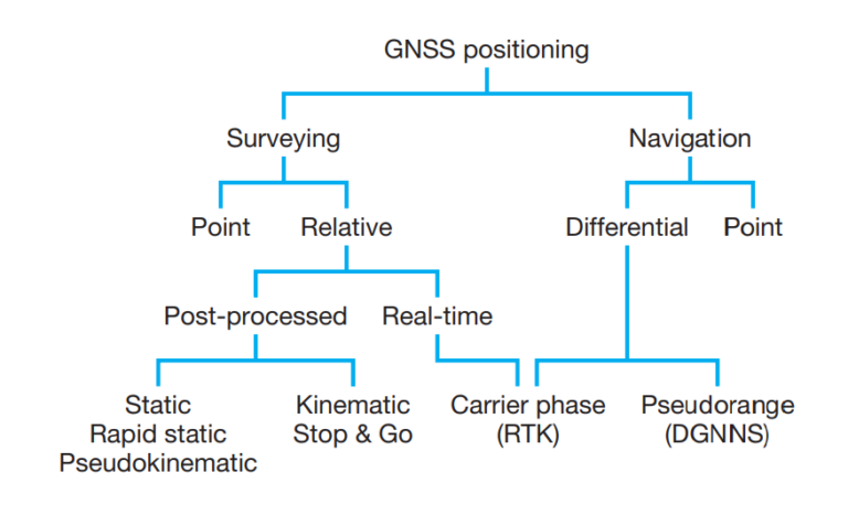
Several different methods are available with which to accomplish a survey. Each method provides a unique set of procedurals requirements for field personnel. In high-accuracy surveys that involve long baselines, the static surveying method with GNSS receivers is the best solution. However, in typical surveys limited to small areas, a single-frequency receiver using rapid static, pseudo kinematic, or kinematic surveying methods may be sufficient. Because of the variability in requirements and restrictions of surveys, there is seldom only one method for accomplishing the work.
GNSS receivers will reduce the time required at each station in a static survey due to the increased number of visible satellites and the improved satellite geometry. The surveying community has used those shown on the left side of the below diagram traditionally. The selection of the appropriate survey method is dependent on the (1) desired level of accuracy in the final coordinates, (2) intended use of the survey, (3) type of equipment available for the survey, (4) size of the survey, (5) canopy and other local conditions for the survey, and (6) available software for reducing the data.
Kinematic Surveying
In many areas of surveying, speed and productivity are essential elements to success. In satellite surveying, the most productive form of surveying is kinematic surveying. It uses relative positioning techniques with carrier-phase observations. These surveys can provide immediate values to the coordinates of the points while the receiver is stationary or in motion. Its accuracy is typically less than that obtainable with static surveys but is adequate for most forms of surveys. It has applications in many areas of surveying including mapping, boundary, construction, and photogrammetry. Let’s have a look
at both the post processed and real-time kinematic surveying methods.
Real-time kinematic (RTK) and post-process kinematic (PPK)
Kinematic surveying can provide immediate results using the real-time kinematic (RTK) mode or in the office using the post-process kinematic (PPK) mode. Kinematic surveying provides positioning while the receiver is in motion. For example, kinematic surveys have been successfully used in positioning sounding vessels during hydrographic surveys and aerial cameras during photogrammetric surveys. In large construction projects, it is used in machine control to guide earthwork operations. It is also useful in Non surveying applications such as high-precision agriculture.
It shares many commonalities with static surveys. For example, a kinematic survey requires two receivers collecting observations simultaneously from a pair of stations with one receiver, the base, occupying a station of known position and another, the rover, collecting data on points of interest. It also uses relative positioning computational procedures similar to those used in static surveys. Thus, it requires that the integer ambiguities be resolved before the survey is started. The main difference between static and kinematic surveying techniques is the length of time per session. In a kinematic survey, observations from a single epoch may be all that is used to determine position of the roving receiver. Establishment of control points using a static surveying method requires much longer sessions than are typically used in kinematic surveys.
Equipment Used in Kinematic Surveying
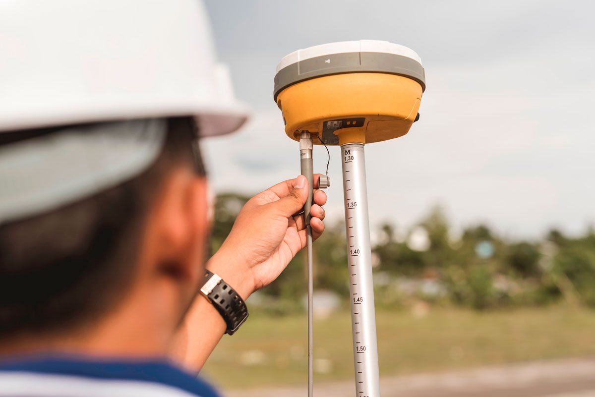
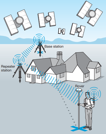
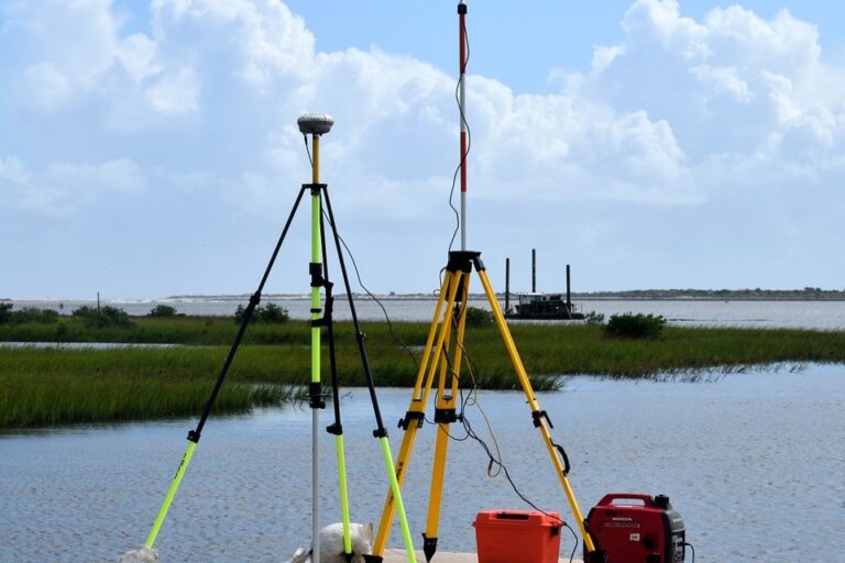
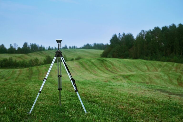
In kinematic surveys, antennas are often mounted on fixed-height rods (2 m) or tripods, minimizing measurement errors and operator obstructions. Adjustable-height tripods and poles can lead to height errors. Using a tribrach for traditional tripods requires careful adjustment of optical plummets. Regularly checking and adjusting the level bubbles is crucial for both fixed and adjustable rods. Misleveling the bubble can cause setup errors, minimized by lower setups. For instance, a 2.000 m tripod with a 2 min misleveling causes a 1.1 mm horizontal positioning error, while a 1.500 m height results in a 0.9 mm error. These errors are typically negligible in satellite surveys but significant in kinematic surveys. Avoid overhead obstructions at base and rover stations, and keep the base receiver location free from reflective objects. Manufacturers provide 100-ft cables to position vehicles away from the base receiver, avoiding multipathing issues. In most RTK surveys, the base receiver’s radio antenna is mounted on a nearby tripod, kept vertical for proper orientation with the rover antenna. High mounting increases the base radio’s range, and repeater stations can extend it further when needed, avoiding obstructions.
RTK surveys also require a radio and its power source, typically an external battery for larger base receiver radios. Ensure a backup power source, such as a vehicle for charging batteries and powering base station radios. A survey controller is essential for managing data collection from both the base and roving receivers.
Communication Methods in RPK Survey
- PPK surveys use a base receiver and a rover to collect data for mapping surveys.
- The base receiver collects data at the same epoch rate as the rover.
- A local CORS station can be used as a base receiver if it is collecting data at the same rate as the rover.
- If a local reference station is not available, the temporary coordinates of the base receiver can be established using its autonomous position.
- The accuracy of the base station’s position can be improved by post-processing its data with an established reference network station.
- PPK surveys are typically used for large surveys with minimal obstructions where the rover can be mounted on a vehicle.
- When collecting data using the true kinematic mode, it is important to set a reasonable epoch rate based on the speed of motion of the rover.
- After the data is collected, it is loaded into the processing software. An advantage PPK surveys have over RTK surveys is that precise ephemeris can be used in the processing.
- The base station coordinates should be established or entered before the rover’s observation file is downloaded.
- After the baseline vectors to the rover are processed, the geoid height at each point must be applied to the geodetic height to determine its orthometric height.
Communication Methods in RTK Survey
Radios:
- Most common method.
- Low-powered radios are often integrated into receivers.
- 157-174 MHz band is generally license-free.
- Higher frequencies (450-470 MHz) require an FCC license.
- Requires careful channel selection to avoid interference.
- Range is limited by radio power and obstructions.
- Repeaters can extend the range.
Data Modems:
- Utilize cellular networks for data transmission.
- Requires cellular coverage.
- Incur monthly service fees from the cell provider.
- Higher data latency compared to radios.
Wireless Internet:
- Uses internet connection for data transmission.
- Requires internet connectivity at both base station and rover.
- Higher data latency compared to radios

Communication Challenges:
- Cable Issues: Breaks in cables can cause intermittent or complete communication loss.
- Radio Range Limitations: Limited by radio power and obstructions.
- Data Latency: Can be significant with data modems and internet connections.
Real-Time Networks (RTN):
- Eliminates the need for a dedicated base station.
- Utilizes a network of base stations connected to a central processing unit.
- Central processor models errors (ionospheric, tropospheric, ephemeris) and provides corrections to the rover.
Advantages:
- Improved accuracy due to error modeling.
- Consistent coordinate system across the network.
- Reduced operational costs by eliminating the need for a dedicated base station.
Disadvantages:
- Relies on network infrastructure (internet, cellular).
- Can be susceptible to data latency issues.
- May not work reliably in areas with poor cellular or internet coverage.
In Conclusion
Key Points:
- Reliable communication is crucial for accurate RTK positioning.
- RTNs offer a more efficient and potentially more accurate solution compared to traditional RTK setups with a single base station.
- Careful consideration should be given to the communication method based on the specific survey requirements and environmental conditions.