How Auto-Leveler fit in Surveying
Auto Leveling is important in surveying as it identifies quantity measured in surveying engineering that lead to the determination of the height of points and the height difference between points. The meaning of leveling in surveying engineering is often the same as the height difference.
First lets define Surveying:
The set of operations that are performed to determine or display the relative position of features and features located on or near the surface of the earth, whether artificial or natural, by measuring the distance, height, angles and extension of a number of points relative to each other or to other points, called control points, and in most cases lead to the preparation of a map for various uses is called surveying.
According to the above definition, a surveyor has 2 basic activities:
- Measuring data between existing features (such as measuring length and angle in a survey) to prepare a map. In other words, any measurement that is taken to determine the location of features is called a “survey”.
- Implementing features on the ground (such as implementing the main axis of a highway or implementing the plan of a building).
In other words, it is a science that attributes the three elements Z, Y, X to any point on or near the surface of the earth using appropriate techniques; or it can be said that mapping is a science that displays the image of all or part of the earth’s surface on a screen.
The literal meaning of mapping: Mapping is formed from the two words map + survey It has been said: To crop means to transfer natural or artificial features to a smaller scale on the screen.
Map preparation process:
- Collect data of land features from the ground
- Imaging features on a computational base plane
- Displaying and transferring them onto a paper sheet at a specific scale
Method of working in surveying:
- Observations: length, angle, height difference
- Performing calculations and processing on the observations of the previous stage
- Obtaining Z.Y.X
Divisions of the science of Survey
Plane surveying: Limited areas where the effect of the curvature of the earth on observations can be ignored. In this case, the sum of the angles of the triangle is 180 degrees
Geodetic surveying (Goodesy):
surveying of large areas in which the effect of the chromite of the earth is taken into account and the coordinate system is removed from the perpendicular. As a result, the sum of the internal angles of the triangle will no longer be 180 degrees. In non-planar survey(Geodetic surveying), we will deal with (λ,φ) instead of y,x.
The difference between Plane surveying and Geodetic surveying
Geodesy: In this branch, which is used in large areas, the base surface of calculations is an ellipsoid, and networks of control points are created and developed to maintain the integrity of coordinates in maps and transfer coordinates to construction projects.
Planimetric surveying: In this branch of surveying, only the extraction and display of planar features such as roads and buildings is desired.
Topographic surveying: This branch of surveying aims to capture and display planar and elevation features of terrain simultaneously.
Route surveying: In this branch of surveying, in addition to capturing and displaying planar and elevation features along a short-width route, route design and implementation of its components are also considered.
Underground (Mining) Surveying: In this branch of surveying, in addition to capturing and displaying the planar and elevation features of an underground route such as transportation tunnels and mines, the implementation of the tunnel’s geometric design is also considered.
Cadastral Surveying: This branch of surveying only captures and displays the boundaries and ownership information of the properties in question.
Construction surveying (workshop): In this branch of surveying, only the implementation of the main components of buildings and their associated facilities and their geometric control during implementation are considered.
Aerial surveying (photogrammetry): In this branch of surveying, measurements and so-called surveys are carried out using aerial photographs, and ground measurements and operations are solely for giving coordinates to the photographs and illustrating the features.
Marine surveying (hydrography): In this branch of surveying, the survey and display of the planar and elevation features of the seabed and water areas are of interest.
Cartography: The science, art of drawing maps, the study, and methods of using maps.
GIS: Performing complex analyses on spatial and non-spatial data using data, methods, algorithms, hardware, software, and human resources.
Remote Sensing: Extracting Features from Satellite Images
Now we discuss Leveling
Leveling: Another important quantity measured in surveying engineering that leads to the determination of the height of points is the height difference between points. The meaning of leveling in surveying engineering is often the same as the height difference. Therefore, leveling can be defined as a set of operations that leads to the determination of the height of a point or the height difference between two points relative to each other. The word level refers to the level surface or equipotential surface, and therefore the real meaning of leveling is the measurement of the potential difference between two points, the geometric interpretation of which is the difference in distance between the level surfaces passing through the two desired points. Leveling in surveying is generally carried out with the following objectives:
- Producing topographic maps (elevation and depression of the ground surface)
- Obtaining the slope of a stretch
- Creating and controlling horizontal surfaces
- Obtaining the shape of vertical sections (profiles)
- Calculating the volume of earthworks
Ways Leveling works in Surveying:
1- Direct leveling methods Direct leveling is based on comparing an unknown height with a known length in the vertical direction (plumb extension).
2 Leveling with a level hose In many small construction works where we need to equalize the height or measure the height difference, we use a transparent plastic hose called a level hose. In leveling with a level hose, the property of the water being level in the relevant containers is used.
3 Leveling with a level rod This method is mostly used in surveying operations related to construction projects. The tools for this leveling are a rod, a level, and an index. Instead of the index, a plumb line and a meter can also be used.
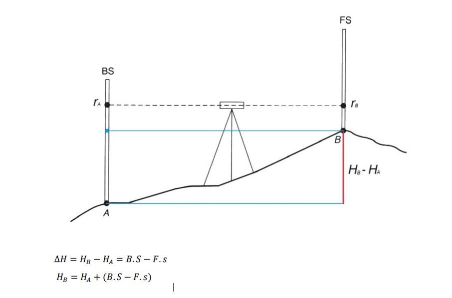
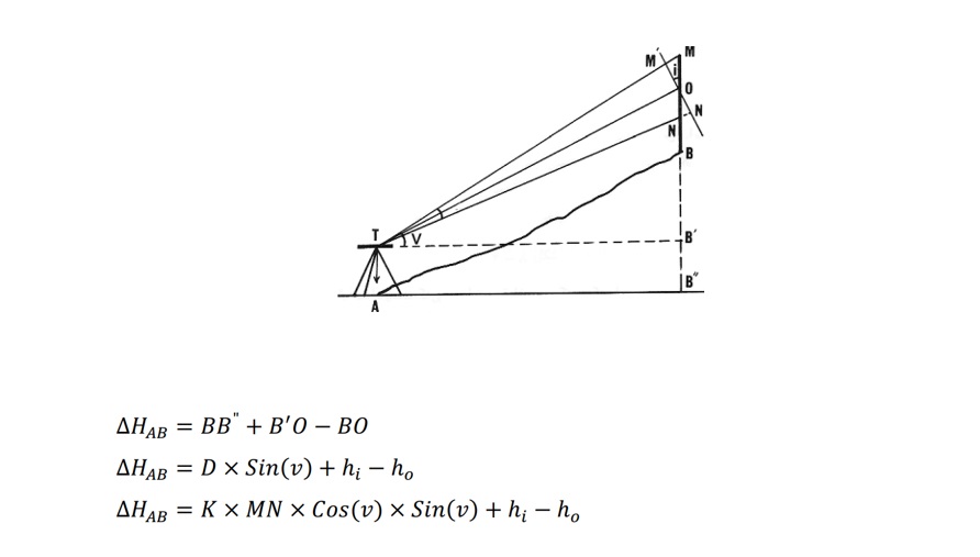
Leveling with a camera and index in the direct method or geometric leveling: a leveling device and usually two graduated indexes are used. According to the figure below, in this method, we place the leveling camera approximately in the middle of two points A and B in such a way that it has a view of two points.
Some definitions related to leveling:
Benchmark (B.M): Fixed points whose heights are known to us.
Station: Location of the surveying instrument
Back reading (B.S): The first levelling instrument reading at each new station setting
Front reading (F.S): The last levelling instrument reading at each new station setting
Intermediate reading (M.S): Any levelling instrument reading that is neither B.S nor F.S
Turning point (T.P.) is an intervening point between two bench marks upon which point foresight and back sight rod readings are taken as a turning point
Types of Leveling methods with a Levelling instrument.
Gradual: In each levelling instrument setup, we only have two readings, back and front
Radial: In each setup, in addition to the back and front readings, we also have intermediate readings
Combined: A combination of the two above methods
Gradual leveling: If the two points whose height difference we want to find are far apart or the slope of the ground is high in a way that it is not possible to find the height difference with a single station setting, gradual leveling is used. In gradual leveling, we only have two readings back and forth each time the levelling instrument is set up. In the figure below, the height of point S is specified and the goal is to find the height of point T.
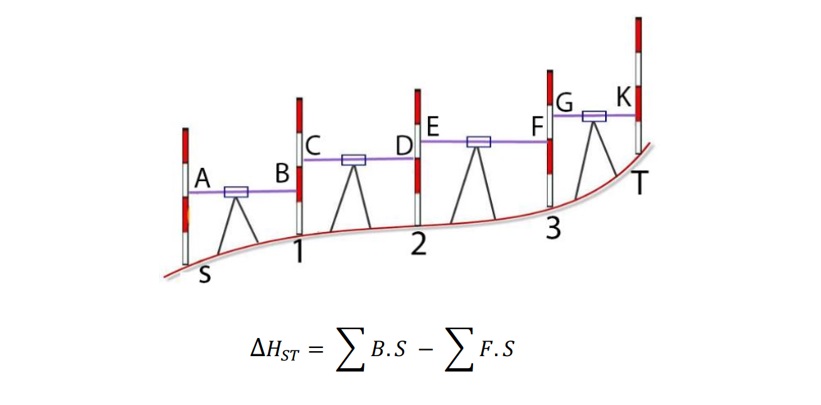
Gradual leveling is usually used when, for one of the following reasons, we cannot calculate the height difference of two points by placing the levelling instrument once:
The first case: if the distance between the index and the leveler is more than 422 meters, you should use auxiliary points
Let’s gradually reach the height of the second point
Second case: if there are too many natural and artificial obstacles and it is not possible to see directly
Third case: If the height difference between two points is more than 4 meters (index height)
In gradual leveling, it is usually done back and forth to control the leveling work
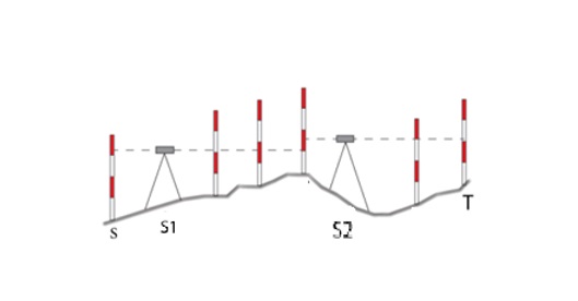
Radial Leveling: This type of leveling is mostly used when more than two readings are done by placing the leveling device in the right place. This method is mostly used in topographic surveys and preparation of longitudinal and transverse profiles. The first reading from each station is listed as the rear reading, the last reading as the front reading, and the rest as intermediate readings in the table. The important point in radial alignment is that after changing the position of the camera, we must read a common point between the two apertures.
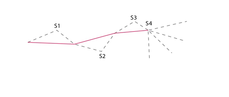
Combined leveling: In civil works, to increase the work speed, a combination of the above two methods is usually used. The lower the number of our stations, the higher the speed and accuracy of the work. Therefore, by placing the camera, we take the maximum possible points and move the camera only when one of the following situations occurs.
: • The difference in height is greater than the length of the index.
Indirect leveling method (triangulation)
In indirect leveling, the height difference is calculated based on the measurement of other parameters such as length and angle and using a series of relationships and equations.
Barometric leveling
Barometric leveling – an approach that almost seems too simple to be true, as it uses an already known method in a slightly different way. The range of the elevation change almost exceeds 1000 ft relative to pressure change in the atmosphere of about 1 inch of mercury. For instance, a temperature difference can generate odd changes that could also change pressures without the need of varying the elevation. Of course, on a single day there exists a diurnal range for differences of 100 ft or so for normal barometric pressure. These z variations are termed the diurnal range. Owing to the air pressure changes with the weather in barometric levelling different techniques can be employed to acquire the correct elevation difference. A control barometer remains for the benchmark (base) measurement while the roving instrument is taken to the desired points. Readings are taken from the base barometer and alongside pressure and time temperatures are recorded, for intervals of 10 min.
Different critical points are observed with a time factor, temperature, level and roving barometer and they are adjusted afterward at relevant changes noted on, or for these.
The height obtained by this method has no engineering value and is only used in non-precise works
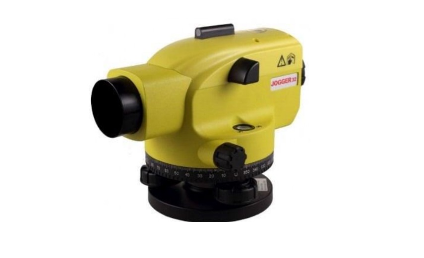
Instruments used in Leveling:
A) Level is an instrument which is used for observing staff reading on leveling staff kept over different points.
Types of Level:
- Dumpy Level. In this level the telescope is restricted against movement in its horizontal plane and telescope is fixed to its support. A bubble tube is provided on the top of the telescope.
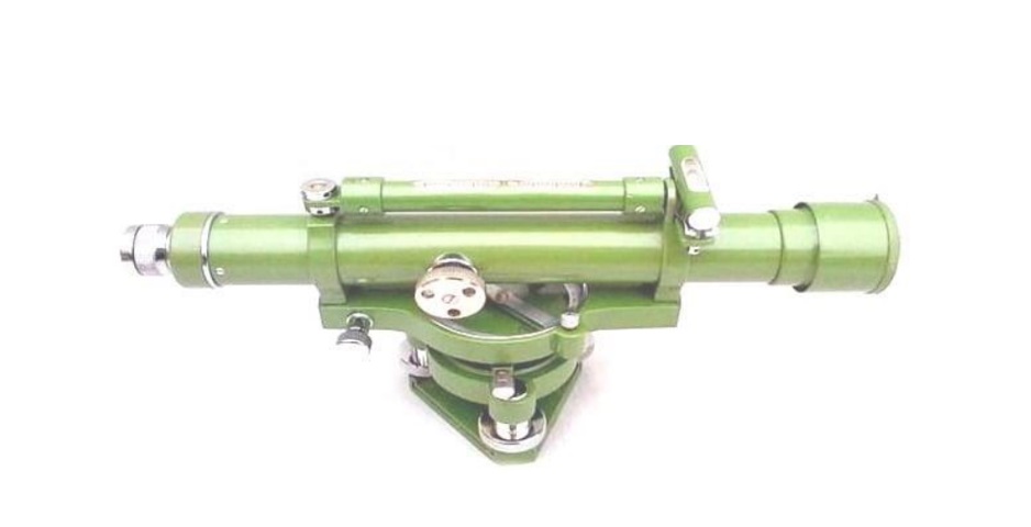
2- Tilting Level. Consist a telescope which enabled for the horizontal rotation as well as rotation about 4 degree in its vertical plane. Centering of bubble can be easily done in this type of level. But, for every setup bubble is to be centered with the help of tilting screw. The main advantage of tilting level is it is useful when the few observations are to be taken with one setup of level

3- Automatic Levels. Is the most commonly used instrument in leveling. The telescope is fixed to its supports. Circular spirit can be attached to the side of the telescope for approximate leveling. For more accurate leveling, compensator is attached inside the telescope
4- Digital Level is an accurate instrument used for accurate leveling. Operation of digital levels is based on the digital processing of video indications of a coded staff.
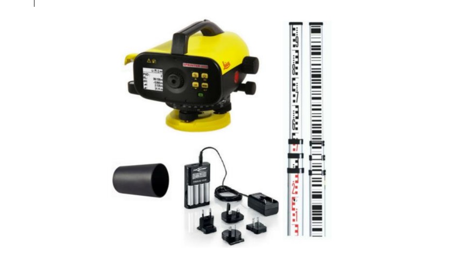
B) Staff. Is simply a large ruler, available in lengths of 3, 4 or 5 meters and usually made of aluminum with telescopic sections. Reading the Staff Color Alternates every meter each graduation is 100mm, each “E” is 50mm meter height & 1/10m is located in lower 50mm each Part of the E is 10mm millimeters are interpolated staff is read to the millimeter
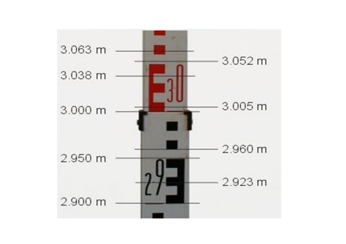
Staff Reading
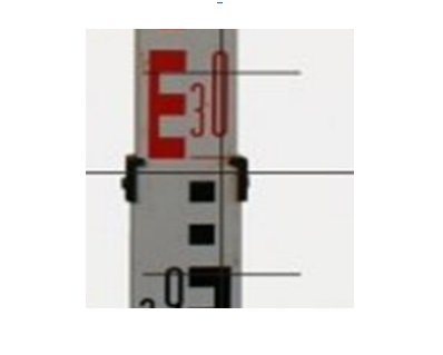
Stadia Reduction The middle line is the line of Collimation, the short lines are called stadia lines usually stadia multiplier is 100
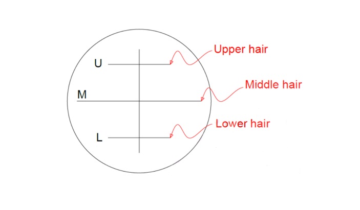
Collimation is an imaginary line that passes through the level instrument at the cross hairs
References:
Ghilani, C. D. and P. R. WOLF (2014). Elementary Surveying: An Introduction to Geomatics . New Jersey, PEARSON.
Uren, J. and B. Price (2010). Surveying for Engineers. UK, PALGRAVE MACMILLAN.